Costa Rica Road Maps and Travel Planning

The legacy 12 Maps page on Tourism.co.cr was originally connected with Costa Rica road maps and travel-planning information from Orbit Travel Network. Older backlink indexes still point to /maps-views/12-maps.html, so this page is preserved and rebuilt around the durable reason people used that link in the first place: planning a Costa Rica trip with a realistic understanding of geography, roads, regions and travel time.
Costa Rica looks small on a map, but visitors quickly learn that distance is only one part of route planning. Mountains divide the country, rivers shape road networks, bridges matter, ferry schedules can determine the best route, and weather can turn an easy-looking drive into a slower day. A good Costa Rica road map helps travelers think in regions rather than straight lines.
How to read a Costa Rica travel map
Costa Rica sits between Nicaragua and Panama, with the Pacific Ocean on the west and south and the Caribbean Sea on the east. The Central Valley, where San Jose and the main international airport area are located, is the country’s most important transportation hub. From there, routes spread toward Guanacaste, the Central Pacific, the Caribbean coast, the Northern Plains, Monteverde, and the South Pacific.
The first planning mistake is assuming that two places are close because they appear close on a flat map. San Jose to Jaco is straightforward for many travelers, but San Jose to Monteverde, Arenal to Manuel Antonio, or Tamarindo to Tortuguero are very different journeys. Curving mountain roads, construction, rain, slow trucks and river crossings can make travel time more important than distance.
For practical planning, use maps in layers:
- A national map to understand where each region sits
- A road map to check main highways and mountain crossings
- A regional map for beaches, parks and local towns
- A GPS app for turn-by-turn navigation
- Offline maps as backup for rural areas with weak signal
Main regions to map before a trip
The Central Valley includes San Jose, Alajuela, Heredia and Cartago. It is the arrival point for many visitors through Juan Santamaria International Airport and the best base for museums, coffee regions, Poas Volcano, Irazu Volcano and urban logistics. Routes from the Central Valley can reach the Pacific, Caribbean, Arenal and Monteverde, but each direction has different road conditions.
Guanacaste and the North Pacific are often reached through Daniel Oduber International Airport in Liberia. This region includes Liberia, Papagayo, Tamarindo, Flamingo, Playa Conchal, Nosara, Samara, Rincon de la Vieja and Santa Rosa. Distances can feel manageable, but beach-to-beach drives may involve unpaved sections, seasonal river crossings or slower coastal routes.
The Central Pacific includes Jaco, Herradura, Tarcoles, Quepos, Manuel Antonio and Dominical. It is one of the easier regions to map because the coastal highway connects many destinations, but traffic near beach towns and bridges can still affect timing. This region pairs naturally with San Jose, Carara National Park, Manuel Antonio National Park and the South Pacific.
The South Pacific and Osa Peninsula require more careful planning. Uvita, Drake Bay, Puerto Jimenez, Golfito and Corcovado National Park are rewarding but spread out. Some routes involve boats, gravel roads or longer drives than visitors expect. A map is essential here because one destination on the Osa is not automatically convenient to another.
The Caribbean coast includes Limon, Cahuita, Puerto Viejo, Manzanillo and Tortuguero. The southern Caribbean is reached by road, while Tortuguero is commonly reached by boat or small aircraft. Mapping this region means understanding not only highways but also docks, canals, transfer points and the timing of ground-plus-boat travel.
The Northern Plains and Arenal area include La Fortuna, Arenal Volcano, Lake Arenal, Cano Negro and routes toward Sarapiqui. This region connects well with Monteverde, Guanacaste and San Jose, but the drives can be slow because of mountains, lake roads and weather. The Arenal-to-Monteverde transfer is the classic example: it looks close, but the road route is not a simple straight line.
Road maps, GPS and offline planning
Modern GPS apps are extremely useful in Costa Rica, especially Waze and Google Maps. Local drivers often rely on Waze for traffic, police reports, construction and alternate routes. Google Maps is helpful for offline downloads and general orientation. Even so, travelers should not treat any app as perfect. Road names, rural entrances, one-way streets, private roads and seasonal conditions can still create confusion.
Before leaving a hotel or town, download offline maps for the next region. Save the location of the next hotel, national park entrance, ferry dock or meeting point. If you are driving to a beach house, eco-lodge or rural property, ask for written directions in addition to the GPS pin. Many Costa Rican addresses still use landmarks, and a small local detail can save a long wrong turn.
For road trips, build routes around daylight. Night driving in rural Costa Rica can be difficult because of rain, fog, pedestrians, bicycles, animals, narrow bridges and limited lighting. A map may show that a drive is possible, but a good itinerary asks whether the drive is pleasant, safe and sensible after a full travel day.
Legacy 12 Maps listing
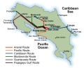
The historical directory entry described 12 Maps as a Costa Rica road-map resource with information for vacations through Orbit Travel Network. Older visitor reviews complained that the maps were not visible on the original listing, which is exactly why this page has been rebuilt as a stable planning guide instead of leaving users on a broken directory fragment.
For broader planning, continue with the main Costa Rica map page, the Costa Rica geographical division guide, driving in Costa Rica, Costa Rica travel tips and the national parks section.
Frequently asked questions
What was the original 12 Maps listing on Tourism.co.cr?
The legacy listing pointed visitors to Costa Rica road maps and travel-planning information from Orbit Travel Network. The original external map resource is historical, so this page now preserves the travel-map intent with current planning context.
Do visitors need road maps for Costa Rica?
Yes. GPS apps are useful, but Costa Rica's mountains, rivers, ferry routes, rural roads and weather can make travel times longer than distances suggest. A regional map helps visitors build realistic itineraries.
What are the main Costa Rica regions to map before traveling?
Key regions include the Central Valley, Guanacaste and the North Pacific, the Central Pacific, the South Pacific and Osa Peninsula, the Caribbean coast, the Northern Plains around Arenal, and the cloud forest areas near Monteverde.
Are Costa Rica driving times predictable?
Not always. Road conditions, rain, bridges, trucks, mountain curves and ferry schedules can change travel times. Visitors should plan by driving time and route quality, not only by kilometers.